Approfondimento

Governet Project - Work Package n. 2
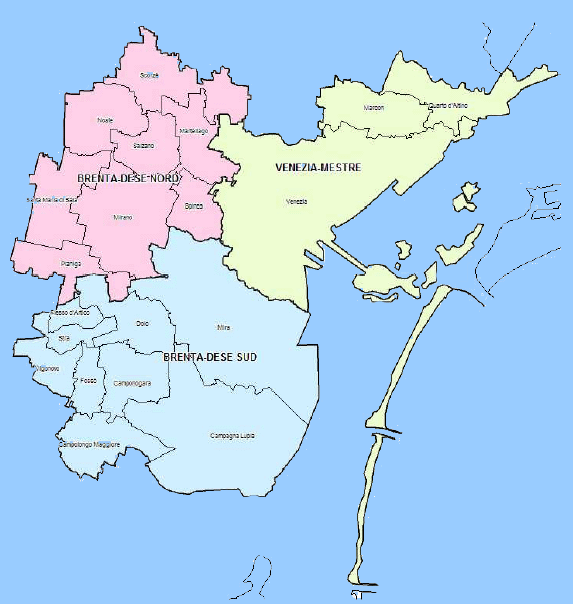
Case study area: periurban area of Mestre (Italy)
Authors: Luca Ciresola, Oreste Del Re, Giuliano ZanonCOSES - Consorzio per la Ricerca e la Formazione
August 2004
The Soil
The provincial territory is covered with a superficial layer of earth that is loose with a medium to high permeability, is quite variable laterally, and is tied to morphological conditions (argillaceous and peaty in depressed zones interspersed with sandy areas in zones raised by river banks and dunes).
The soil in the North Brenta-Dese area is sowable (corn, fodder, soy, grapevines, beetroot), though it is also obviously used for residential and productive uses. The municipalities of Venice, Marcon, and Quarto d'Altino differ clearly, from this standpoint, from the residential density of the Lagoon of Venice and of Mestre (as well as the construction in Marghera) and the sowable lands with wheat, beetroot, soy, corn, and fodder over most of the eastern zones. In South Brenta-Dese, the soil characteristics are similar to those more north in the province, with prevailing mixed sowable lands.
The municipalities of the "Riviera del Brenta" are characterized and connected one to another through a strong territorial and cultural identity. The Riviera represents the historical axis along which the summer villa system was developed for wealthy Venetian families and today presents a marked residential presences as well as a strong specialized production. The strong functional and cultural dependence at Porto Marghera (in particular with regards to the most eastern part of the Riviera) has been substituted, in recent years, by a consciousness of being physically located between two large centres, Venice and Padova, and the proximity to networks with connect with these two cities, as well as a consequential series of aspirations towards the development of functions (residential, tourist, productive, and logistical) which are not always reciprocally compatible.
Agriculture
Most of the territory that has not been urbanized by the municipalities included in this study can be described as cultivated land. Cultivated lands have been subjected in the last few years to considerable fluctuation in quantitative terms and even techniques and types of cultivation have changed. The intensive cultivation of corn has modified traditional cultivation rotations, favouring monoculture, mechanization, and the use of herbicides, as well as elimination of fences, which until the middle of the 1900's were of great importance in the biotope. These elements have impoverished and reduced the biodiversity in the area of this study. At one time, a primary landscaping element was the intensely cultivated countryside. Today, the North-east development model has also includes land which was primarily agricultural.
The plain-like land and its deep soils, found throughout the area of study, allow for both extensive and intensive agriculture. In some areas, there is a predominance of corn monoculture, destined for bovine feed. Other crops commonly grown in the area are soy, grapevines, and beetroot. There are also many orchards (particularly peach, kiwi, pear, and, in smaller quantities, apples). The current trend is to grow specialized crops such as vegetables (radishes, legumes, potatoes, onions, wine grapes), sometimes in greenhouses. Cultivation methods are becoming increasingly important, whereas until a few years ago, cultivation was completely mechanized and used fertilizers and herbicides. The trend is now towards "organic" agriculture. Agricultural businesses have also begun to link organic agriculture to agritourism.
With regards to the type of crops cultivated, the most common appears to be grain, which takes up most of the growing area. This is particularly true for some municipalities, specifically Noale (where 73.6% is used for grain) and Campolongo Maggiore (at 69.8%).
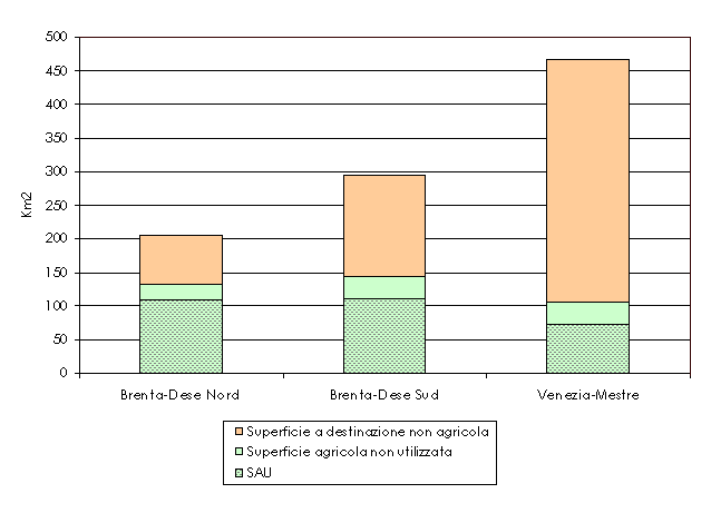
Mestre's urban periphery has a total agricultural area of 381 km˛, almost 40% of the area itself. This number, while not inconsiderable, is lower than the provincial average (60%). The areas with the largest total agricultural areas are South Brenta-Dese (144 km2) and North (131 km˛). The latter also possesses the highest amount of designated agricultural area within the territorial expanse. Lastly, Venice-Mestre has 105 km2.
The utilized agricultural area (UAA) in Mestre's urban periphery is 294 km˛, 77% of its total. In the interior, the South Brenta-Dese has a UAA of 112 km2 (38% of the area's UAA), and slightly more than that of North Brenta-Dese. This indicates how agricultural spaces in this area are largely used (relationship between UAA/total agricultural area is 83.2%, compared to 77.7% in South Brenta-Dese).
In Mestre's urban periphery, there are 11.224 agricultural businesses, almost half the businesses in the province. In North Brenta-Dese, with 5,380 businesses, this amounts to 48% of agricultural businesses in the area, with another 39% active in South Brenta-Dese (4,388 businesses), the remaining 13% in Venice-Mestre (1,456 businesses).
The North and South Brenta-Dese areas report a lower average number of working days and a lower contribution towards the non-family workforce. In the Mestre's urban periphery, agricultural working days are 1,088,501 (of which 1,030,764 are family workforce), with an average number per busines of 97.
Almost all the businesses of the area have less than 5 hectares of land, and 50% of these have less than 1 hectare. Farms are extreme spraying, in comparison with data available from the latest census (year 2000) and that of 1990 (when the last agricultural census took place). The reduction in the number of farms is proportionally larger that the reduction of UAA. This means that the average surface area of farms has increased.
The South Brenta-Dese area is well-established in its industrial vocation, the evidence of this being in the well-known footwear industry. The role of the agricultural sector is therefore marginal, as shown in the low employment numbers for that sector. Nevertheless, the area is distinguished for its agricultural community and the high number of agricultural areas (available and utilized) as well as the high density of farms. This agricultural landscape is fragmented by diffuse residential development, and is therefore classified as "urbanized countryside", as are the entire Veneto plains.
The percentage of land occupancy by farms is among the lowest in the province. This is a result of the intense parcelling out of landed property (almost 10% of the UAA is held by farms with less than 1 hectare of land). To complete the picture of this residual agriculture, there is a low percentage of young farm heads and a low UAA of farms with employees and with lease agreements.. Agricultural reality is distinguished by the presence of small, part-time farms alongside medium-sized professional farms, managed with economy or individually. The cultivation concentration index has a relatively high value (0.88) for the prevalence of grain cultivation. Fruit and ornamental plant farms and specialized vegetable growing represent the area's only specializations. Grapevine cultivation is relatively developed, cultivated lands survive because of income compensation, and animal breeding plays a minor role. The agritourism sector has considerable potential, encouraging integration of environmental activities in the area.
Between 1990 and 2000, South Brenta-Dese reported a decline in UAA clearly smaller than the number of farms, with a subsequent increase in average size. The process, the result of competition between residential and industrial use, has influenced, to varying degrees, all the interior municipalities except Dolo, where a fairly consistent number of farms experienced a decrease in utilized agricultural area.
In North Brenta-Dese, as in the South, there is a high residential concentration next to a diffuse agricultural community. This area reports the highest amount of land within the territorial expanse area designated for agricultural use, as well as a more intense use of this land. Furthermore, there is a higher density of farms and a lower average land area. The period between census (1990-2000) highlights a decrease of 8.9% in the number of farms, and a -5.8% in UAA. The average UAA has grown thus grown by 4.6%. The slow but gradual process of farm concentration is caused by the strong traditional fabric of small and medium-sized farms. There are particular trends in the Municipality of Martellago, where the UAA is growing, and in Mirano and Spinea, where there is an average reduction in farms.
In North Brenta-Dese, approx. one fifth of businesses are agricultural. This primary role is concentrated largely in the Municipalities of Noale, Santa Maria di Sala, and Scorzè. The opposite is true for Martellago and Spinea, largely as a result of greater residential density (in relation to territorial area) and therefore a lesser availability of useable area.
Agriculture here is constrained by the considerable parcelling off of farms. In fact, UAA covers little more than 50% of the territory, with 12.1% held by farms with less than 1 hectare of land. Furthermore, the lowest percentage values for non-family working days (4.8%) are reported here, as well as for UAA for farms with employees (11%), leased UAA (13.5%), and organic agriculture (0.3%). Agriculture in this area, as in South Brenta, is "traditional", with fewer average working days per farm and a lower contribution for non-family workers. The diffuse specialization in the cultivation of grains and other seeds raises the concentration index to 0.87.
The Venice-Mestre profile is typical of a highly urbanized and industrialized area, with high population density, small agricultural expanse, and low concentration of farms (22.5% of the area is being used, while UAA is only 15.8% of the provincial territory). The stable employment load is equally modest in agriculture. Farms are medium to large in size, many of them employing workers (37.4% of UAA).
Although agriculture has a small presence here, it is particularly dynamic, with the highest participation by young women in farm management and the highest leased UAA, testifying to a high incidence in capitalistic-type investments.
Between 1990 and 2000, Venice-Mestre reported a decrease in the number of farms that was almost double that of other areas (-22%) and in the UAA (20.6%). The increase of average UAA was therefore lower than in other areas. This overall negative dynamic is largely attributable to the municipal capital city, which lost more than 26% of its farms and UAA. The Municipality of Marcon instead increased its farms by 3.5%, though it experienced a slight decrease in average area used. In Quarto d'Altino, the number of farms decreased, though the average size became larger.
In 2003, agricultural businesses registered in the Province of Venice amounted to 12,305 (17% of all businesses). Compared to the previous year, these decreased by 8.6% .
Specialized areas and agribusiness farms
Faced with a saturated market for food products, businesses must modify their products or differentiate themselves to meet consumer tastes. Analysis of structural changes in the agribusiness product market confirms the growth potential of quality foods that are certified at a municipal level. Local products are labelled DOC, DOP, IGP, and IGT, and traditional products are listed in the Region of Veneto's Traditional Agribusiness Products List.
The productive specializations (in terms of cultivation and of the surfaces used for this practice) in Mestre's urban periphery, compared to the entire province of Venice, are:
Local and traditional products from the Mestre's urban periphery are:
The activity of breeding in the urban periphery is focused on birds (more than a quarter of the provincial total), with more than 6,500 farms. The raising of cattle is also common (approx. one third of Venetian breeding), though the number of farms is considerably low (880). The raising of pigs is less common (522 farms). The area with the highest concentration of breeding is North Brenta-Dese (65 farms of 100).
Emerging landscapes
Agricultural has today a significant role to requalificate environmental and to redesign the landscapes. For example San Giuliano park is part of a larger project for the creation of a series of green areas in the surrounding territory and which will include the creation of the Bosco di Mestre (forest) in the next years. This project also include rivers, cycling and footpaths (which will become part of a network of paths that connect the green areas on the terraferma), and a visitor centre.
Areas of planning
The Province of Venice is influenced at various levels by various instruments of economic, territorial, and urban planning. At the regional level, the instruments used are:
Regulatory instruments for the production of goods and environmental services
The regional administration has created, for the 2000-2006 period of community planning, a rural development plan, whose general goal is to consolidate, rationalize, and develop rural activities in an economic, social, and territorial context for Veneto. More precisely, the plan aims to improve come the competitiveness and efficiency of the agricultural, agro industrial, and forestry systems, with the object of a sustained integration of territory, the development of rural communities, the multifunctionality of agriculture, and actions of safeguarding and protecting the environment and rural landscape.
The Region of Veneto has also created a promotional program for its agricultural products that aims at increasing its renown on regional, national, and foreign markets, for farms and local products of quality, and the synergies between agribusiness production and tourism and historical-cultural resources, through means of fruition integrated with tourism, eno-gastronomia, and cultural solutions. Among the primary intervention strategies of the project, there is the development of local and high-quality products, coded according to their designations of origin or quality label, with the aim of rendering the promotion of agricultural products compatible with community orientation in: PDO and PGI products, CGDO and CDO wines, organic products, traditional agribusiness products, products protected by regional labels or other labels compatible with municipal regulations.
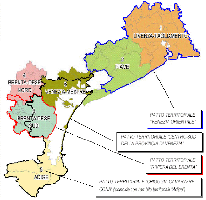
Concerted planning initiatives
The Province of Venice is influenced by numerous concerted planning initiatives regarding various economic sectors. These planning initiatives are connected, directly or indirectly, to the instruments in place at the regional level, in other words the PRS and PTRC. Some of these initiatives developed within the province also refer to the Mestre urban periphery. Among these, the existing Territorial Pacts are the following:
All the same, this progressive contracting of the base agricultural production does not represent, a chronic "crisis" in the sector. In fact, the agricultural sector experienced a complex dynamic of restructuring. This area gradually adapted to new economic circumstances and acknowledged development and functional mechanisms common to other sectors.
Gradually a farm model with strong entrepreneurial capacities emerged and behaviours oriented towards markets and an increase in productivity became diffuse. Farms that operated in a logic of market began growing, while marginally economic farms were cast off. Through specialization processes, farms geared towards crops with a greater economic yield but also require a more attentive production organization and an increase in entreprenuralism.
There remains in a local context, nonetheless, areas in which agricultural production, though marginal, retains a certain importance, both to social ends (employment of the elderly, common presence throughout the territory, etc.) and to private, family consumption ends and/or integration with income derived from other activities.
The agricultural sector is taking the right view not only in terms of sectors, but also in the larger picture of territorial and rural development. In fact, the rural concept includes the social, economic, and cultural factors of a society.
Agriculture on the whole has a fundamental potential to exploit for productive ends and for territorial and environmental realignment. In a context where the primary goal is not "how much" but "what" and "how to" produce, it is auspicious participation that aims for environmental protection and development , safeguarding economic goals as much as possible. Workers and agricultural equipment become strategic resources for a productive use of soils and the protection of farmer income. Agriculture then assumes an important role, non only in the production of foodstuffs, but also as a system of roles and responsibilities that touch on various aspects: production, environmental protection, the wholesomeness of foods, and maintenance of tradition and of a rural culture.
The strong ties of connection and interdependence that define the primary sector and other activity established in the territory, despite some tension and inefficiencies, represent a potential that could be better exploited.
The survival and competitiveness of the agricultural sector can be guaranteed through the identification of strategic opportunities for:
In the Region of Veneto, the measures and forms of intervention in the agricultural sector are outlined in the Piano Sviluppo Rurale (Rural Development Plan, 2000-2006), which includes all participation which favours the primary sector, and can be summarized in the following three objectives:
Fondaco Venezia - Cap. 16 Governet Project
